
In a world driven by automation, precision, and real-time data, one technology is quietly transforming industries behind the scenes: LiDAR. From self-driving cars and smart cities to archaeology and agriculture, LiDAR is becoming one of the most important sensing technologies of the modern era.
But what exactly is LiDAR, how does it work, and why is it suddenly everywhere?
Let’s explore.
What Is LiDAR?
LiDAR stands for Light Detection and Ranging. It is a remote sensing technology that uses laser light to measure distances and create highly accurate 3D maps of objects and environments.
Think of it as a system that gives machines “laser vision.”
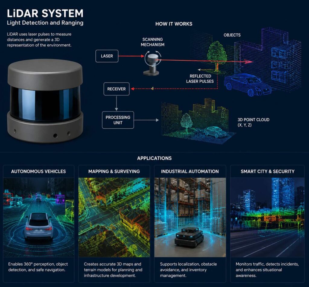
A LiDAR sensor sends out rapid laser pulses toward objects. These pulses bounce back after hitting surfaces, and the system measures how long the light took to return. Since light travels at a known speed, the sensor can calculate the exact distance to the object.
This process happens millions of times per second, creating a dense 3D representation called a point cloud.
How Does a LiDAR System Work?
A LiDAR system consists of several key components working together.
1. Laser Emitter
The laser emitter sends out pulses of infrared light toward surrounding objects. These pulses are extremely fast and often invisible to the human eye.
2. Scanner and Optics
The scanner directs the laser beams across the environment. Some systems use rotating mirrors, while newer solid-state LiDAR systems use advanced electronic scanning methods.
This scanning process allows the sensor to cover wide areas in multiple directions.
3. Receiver
The receiver detects the reflected laser pulses returning from surfaces such as roads, buildings, trees, or vehicles.
4. Timing Electronics
The system measures the “time of flight” — the time taken for the laser pulse to travel to the object and back.
The distance is calculated using the formula:
Distance = (Speed of Light × Time Taken) ÷ 2
The division by 2 accounts for the round trip.
5. GPS and IMU Integration
Many LiDAR systems include:
- GPS (Global Positioning System) for location tracking
- IMU (Inertial Measurement Unit) for motion and orientation detection
Together, they help create accurate geospatial maps.
Types of LiDAR Systems
LiDAR systems are classified based on their application and scanning methods.
1. Airborne LiDAR
Mounted on drones, helicopters, or aircraft, airborne LiDAR is widely used for:
- Topographic mapping
- Forest analysis
- Flood modeling
- Urban planning
2. Terrestrial LiDAR
Installed on tripods or vehicles, terrestrial LiDAR scans ground-level environments.
Applications include:
- Construction
- Mining
- Infrastructure inspection
- Heritage preservation
3. Mobile LiDAR
Mounted on moving vehicles, mobile LiDAR captures roads, highways, and city infrastructure in real time.
It is commonly used in:
- Autonomous vehicles
- Smart transportation systems
- Digital twin creation
4. Bathymetric LiDAR
This specialized LiDAR uses green laser light to penetrate water and map underwater terrain.
Used for:
- Coastal mapping
- River analysis
- Marine research
Major Applications of LiDAR Technology
LiDAR has become a game-changing tool across industries.
1. Autonomous Vehicles
One of the most talked-about uses of LiDAR is in self-driving cars.
LiDAR helps vehicles:
- Detect obstacles
- Measure distances
- Identify lanes
- Navigate safely in real time
Unlike cameras, LiDAR provides precise depth information even in low-light conditions.
Companies developing autonomous systems rely heavily on LiDAR for environmental perception and collision avoidance.
2. Smart Cities and Urban Planning
City planners use LiDAR to create highly detailed 3D city models.
Applications include:
- Traffic management
- Infrastructure monitoring
- Utility planning
- Disaster preparedness
LiDAR helps governments design smarter and safer urban environments.
3. Agriculture and Precision Farming
Farmers use LiDAR-equipped drones to monitor crops and analyze field conditions.
Benefits include:
- Crop health assessment
- Irrigation optimization
- Soil analysis
- Yield prediction
This improves productivity while reducing resource waste.
4. Forestry and Environmental Monitoring
LiDAR can penetrate forest canopies and measure tree heights, biomass, and vegetation density.
It is widely used for:
- Deforestation tracking
- Wildlife habitat analysis
- Carbon stock estimation
- Wildfire risk assessment
Environmental scientists depend on LiDAR for climate research and ecosystem management.
5. Construction and Civil Engineering
Construction companies use LiDAR for:
- Site surveying
- Progress monitoring
- Structural analysis
- Building Information Modeling (BIM)
LiDAR speeds up project planning while improving accuracy.
6. Archaeology and Historical Discovery
LiDAR has revolutionized archaeology by revealing hidden ancient structures beneath dense vegetation.
Researchers have discovered:
- Lost cities
- Ancient roads
- Buried temples
This technology allows archaeologists to study landscapes without excavation.
7. Disaster Management
LiDAR plays a crucial role in predicting and managing natural disasters.
Used for:
- Floodplain mapping
- Landslide detection
- Earthquake analysis
- Coastal erosion monitoring
Accurate terrain data helps emergency agencies respond faster and save lives.
8. Mining Industry
Mining companies use LiDAR for:
- Terrain modeling
- Volume calculations
- Safety inspections
- Equipment navigation
The technology enhances both efficiency and worker safety.
Advantages of LiDAR
LiDAR offers several major benefits over traditional sensing methods.
High Accuracy
LiDAR provides centimeter-level precision for mapping and measurement.
Fast Data Collection
Millions of points can be captured every second.
3D Mapping Capability
LiDAR creates detailed 3D models of environments and objects.
Works in Low Light
Since it uses laser pulses, LiDAR performs well even at night.
Automation Friendly
Ideal for robotics, drones, and autonomous systems.
Challenges and Limitations of LiDAR
Despite its advantages, LiDAR also faces challenges.
High Cost
Advanced LiDAR systems can be expensive, although prices are decreasing rapidly.
Weather Sensitivity
Heavy rain, fog, or snow may affect performance.
Large Data Processing Requirements
LiDAR generates massive datasets that require powerful computing systems.
Reflective Surface Issues
Certain materials can absorb or scatter laser pulses, reducing accuracy.
The Future of LiDAR
LiDAR technology is evolving rapidly.
Emerging trends include:
- Solid-state LiDAR
- AI-powered mapping
- Smaller and cheaper sensors
- Integration with edge computing
- Real-time digital twins
As costs continue to drop, LiDAR is expected to become a standard component in robotics, transportation, defense, and consumer electronics.
Experts predict that LiDAR will play a major role in the next wave of intelligent automation.
Final Thoughts
LiDAR is no longer just a niche technology used by scientists and engineers. It is now at the center of innovation across transportation, infrastructure, agriculture, and environmental science.
By enabling machines to “see” the world with extraordinary precision, LiDAR is helping industries become smarter, safer, and more efficient.
As autonomous systems and smart technologies continue to grow, LiDAR will likely become one of the foundational technologies shaping the future of our connected world.
Whether it’s guiding self-driving cars through busy streets or uncovering hidden ancient civilizations beneath forests, LiDAR is proving that the future truly belongs to intelligent sensing systems.